

Files
Download Page 1 and index as a .pdf file (3.3 MB)
Download Page 1 (148.0 MB)
Download Page 2 (148.0 MB)
Download Page 3 (148.5 MB)
Download Page 4 (147.8 MB)
Download Page 5 (148.6 MB)
Download Page 6 (148.4 MB)
Download Page 7 (148.3 MB)
Download Page 8 (147.9 MB)
Download Page 9 (148.3 MB)
Download Page 10 (147.9 MB)
Download Page 11 (147.8 MB)
Download Page 12 (148.5 MB)
Download Page 13 (148.2 MB)
Download Page 14 (148.3 MB)
Download Page 15 (148.2 MB)
Download Page 16 (148.6 MB)
Download Page 17 (148.1 MB)
Download Page 18 (149.0 MB)
Download Page 19 (148.7 MB)
Download Page 20 (147.8 MB)
Download Page 21 (148.2 MB)
Download Page 22 (148.4 MB)
Download Page 23 (148.0 MB)
Download Page 24 (148.3 MB)
Download Page 25 (147.6 MB)
Download Page 26 (148.3 MB)
Download Page 27 (148.0 MB)
Description
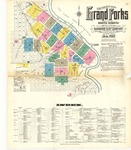
1912 map for Grand Forks, North Dakota. Scale of 1:600 (50 feet=1 inch). 27 total pages, each measuring 64 x 54 cm. Index, key, and boundaries for all pages included on the first page.
Publication Date
1912
Publisher
Sanborn-Perris Map Company
Keywords
Grand Forks, Grand Forks County
Rights
The Chester Fritz Library provides access to these materials for educational and research purposes. Rights assessment remains the responsibility of the researcher.
Recommended Citation
Sanborn Map Company, "Grand Forks, 1912" (1912). Sanborn Maps of North Dakota. 151.
https://commons.und.edu/sanborn-maps/151