


Files
Download
Download Full Text (57.9 MB)
Description
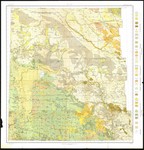
Soil map, reconnoissance survey, western North Dakota. Shows soil types by colors and symbols. Also shows counties, towns, and railroads. 1 map : color ; 91 x 85 cm. Scale 1:380,160. 1 in. equals 6 miles.
Date of Work
1908
Disciplines
Geography
Recommended Citation
Lapham, Macy H.; US Bureau of Soils; and A. Hoen & Co. Lith., "1908 North Dakota Soil Map" (1908). William Langer Papers. 33.
https://commons.und.edu/langer-papers/33
Comments
Image of map provided by the State Historical Society of North Dakota (SHSND). Permission granted for use in the Commons; further reuse requests must be directed to the SHSND.